We explain what a planisphere is, its types and characteristics. Also, what is a celestial planisphere.

What is a planisphere?
A planisphere is a representation of the earth's sphere in a two-dimensional plane. It is a scale map that reproduces the Earth's surface with the distribution of the continents and oceans.
Planispheres are frequently used in academic, school and scientific fields, since they provide precise information and allow the Earth's surface to be studied in a practical and detailed way.
Unlike a globe, which shows a three-dimensional representation of the Earth, the two-dimensional nature of the planisphere requires the use of a cartographic projection, that is, it requires the use of mathematical calculations to be able to represent the spherical surface of the planet on a plane.
In all cases image distortion is inevitable. This is because it is not possible to faithfully represent a spherical surface in a plane without some type of deformation occurring.
The planispheres are a reflection of the moment and era in which they were created. For example, planispheres prior to the 15th century did not include the American continent because European cartographers were unaware of its existence.
Characteristics of a planisphere
The main characteristics of the planispheres are:
- They represent the surface of the Earth in a two-dimensional plane.
- They are usually physical, political or physical-political.
- They are used in academic and school settings.
- They serve to represent phenomena and processes on a planetary scale.
- They require a cartographic projection to go from the three-dimensionality of the Earth to the two-dimensionality of the map.
- There are celestial plans, which show the stars and constellations.
Types of planispheres
The types of planispheres are:
- Physicists. They are maps that show, through variations in colors, the different types of relief (such as plains, mountains and plateaus), the oceans, seas and the main rivers.

- Politicians. They are maps that indicate, through different types of lines and colors, the limits and divisions of each country or State, and their respective capitals and most important cities.
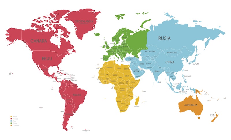
- Physical-political. They are the most frequent maps. They show both physical and political elements through symbols, signs and colors.
Parts of a planisphere

The parts that make up all types of planispheres and that accompany the map image are:
- Qualification. Indicates the content or type of planisphere.
- wind rose. Indicates the cardinal points (north, south, east, west).
- Scale. Indicates the number of times the map is reduced from the actual size of the Earth. It is used to calculate distances.
- References. They indicate what the colors, symbols and signs that appear on the map mean.
In addition to the continents and oceans, planispheres show latitude and longitude with imaginary lines (parallels and meridians), which are used for the geographical location of places.
Regarding the parallels, among others, the line of the equator, the tropics of Cancer and Capricorn and the Arctic and Antarctic polar circles are marked. As for the meridians, among others, the Greenwich meridian and the Greenwich antimeridian or day change line are marked.
Thematic plans
Credits: Industrial Paradise
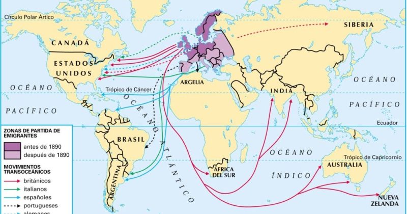
Planispheres can be used to mark different phenomena, processes or events worldwide, whether historical or current. For example:
- Commercial flows.
- Migratory currents.
- Extension of empires and colonial possessions.
- Economic blocks.
- Socioeconomic indicators.
In all cases, the complete image of the Earth's surface allows for a global vision of the mapped phenomena, which favors the analysis and interpretation of the processes that are represented.
History of the planisphere

Credits: Kids Jot Down
The first flat maps are believed to have been created by the Babylonians around 600 BC. c. They showed a limited view of the world, based on observations and what was known about the planet up to that point.
In contrast, during the Middle Ages, maps represented a theocentric view of the world, centered on Jerusalem. These types of maps, called T in O, showed a flat Earth divided into three parts by T-shaped waterways, and all this surrounded by a circular ocean. The best known of these maps is the Hereford Cathedral Discarium, in England. Its particularity is that it contains religious ornaments based on the Bible.
With the Renaissance and the expansion of European exploration, the planispheres became more precise and incorporated information from the new known territories.
Currently, digital cartography makes it possible to produce planispheres with very precise and detailed information on the Earth's surface.
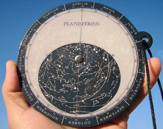
The celestial planisphere
Credits: Diego Rodriguez / Wikimedia Commons
A celestial planisphere is a star chart represented on a plane that, when observing the night sky, helps locate the stars and constellations.
This type of planisphere is usually made up of two disks: a larger one for the constellations and a smaller one for the stars. These discs are joined in the center, on an axis that allows the smaller disc to rotate to identify items on a given day and month.
The creation of these maps also involves the use of cartographic projections that adapt the celestial sphere to a plane, similar to how the Earth's surface is projected on a planisphere.
References
- Garmendia, C. (2020). Cartographic projections: what should I know? Idecor. https://www.idecor.gob.ar/
- Lifeder. (sf). Planisphere. https://www.lifeder.com/planiferio/
- Medellín Planetarium. (sf). Prometheus: celestial chart, a map to follow the sky. https://www.planetariomedellin.org/


