We explain what geographical coordinates are, how they work and various examples. In addition, we tell you what latitude and longitude are.
What are geographic coordinates?
Geographic coordinates are a global geographic reference system that assigns each point on the planet's surface a pair of values with respect to the latitudinal axis and the longitudinal axis of the terrestrial globe. In simpler terms, it is a form of geographical representation that divides the planet into imaginary lines (vertical meridians and horizontal parallels) that when crossed generate points of a specific mathematical value, known as coordinates.
A coordinate is composed of a pair of reference values, each determined by an imaginary axis and expressed in a set of numbers, letters and signs. Normally, the latter consist of sexagesimal degrees, that is, degrees of a circumference, since this allows the spheroidal shape of the planet to be mathematically represented.
The two axes that determine these coordinates are:
- The latitude determined from the Earth's equator and the parallels that follow it to the north and south.
- length determined from the zero meridian and the meridians that follow it to the east and west.
In this way, geographical coordinates normally express the latitude and longitude value of a point on the planet's surface, and thus allow it to be located in an orthographic (geometric) projection of the Earth. This means that each point is located, on a representation of the globe, a number of degrees (and minutes and seconds, if necessary) with respect to the main reference lines.
Thus, for example, the geographical coordinates of the city of New York, United States, are 40°42' N and 74°00' W, which reads: forty degrees and forty-two minutes north latitude and seventy-four degrees west longitude.
See also: Planisphere
Background on geographic coordinates
The certainty of the roundness of the planet has been known since classical antiquity, and The first to calculate the dimensions of the Earth was the Greek Eratosthenes (276-194 BC), who made the first world map with them.
The plan has been lost over the centuries, but based on numerous stories and relationships it has been possible to reconstruct it, and observe that it implied a system of geographical coordinates that divided the known world into baptized segments. spragidas and determined by two axes: one that connected the north and the south (calculated as a parallel that passed through Alexandria) and another that connected the east and the west (calculated as a meridian that passed through Athens, Rhodes and the pillars of Hercules) .
However, The first promoter of a coordinate system similar to the one we know today was the astronomer Ptolemy (c.100-c.170 AD). In his eight-volume study of the known land mass (i.e., Europe, Africa, and much of Asia), titled Geographyproposed the usefulness of this geographic representation system.
Such was the importance of this work, to which little attention was paid during the Middle Ages, that Its rediscovery in the 15th century was key to promoting navigation and exploration of the planet which led to the arrival of Europeans to America.
What is latitude?

Latitude, abbreviated lat and symbolized by the Greek letter phi (Φ), It is the angular distance between any point on the planet and the equator that is, the imaginary line that divides the world into two hemispheres.
It is determined by the parallels each separated from the equator by a fixed number of sexagesimal degrees (and its lower units, minutes and seconds), either in a positive sense (traditionally associated with the northern hemisphere, that is, northern latitude) or a negative sense ( traditionally associated with the southern hemisphere, that is, with southern latitude), until reaching the respective north and south poles of the planet. Thus, the north pole registers 90° North latitude (N) and the south pole 90° South latitude (S).
Latitude not only divides the planet into two hemispheres, but Each hemisphere is divided into three large climatic zones or latitudinal zones which are characterized by presenting clearly identifiable climatic conditions. These areas are identified from two very important parallels in each hemisphere, known as the tropics, and which are located at a latitude of 23° North and South: the Tropic of Cancer in the northern hemisphere and the Tropic of Capricorn, in the south.
The climatic zones of the planet are:
- The intertropical zone that is, the region located between both tropics, like a planetary belt above and below the equator line. Tropical, warm and humid climates predominate, without climatic seasons, as well as jungle, savanna and desert ecosystems.
- The temperate zone which extends beyond the tropical line of each hemisphere, marching towards each respective pole, until reaching the polar circles. It is a region of temperate climates, with four marked seasons, and with the presence of a subpolar climate as you move towards the extremes. Forests, grasslands and deserts predominate in this region.
- The polar zone which lies above the respective polar lines of each region, to the north and south poles, which constitute the ends of the Earth's axis of rotation. These regions have a frigid climate, with six-month seasons of sunlight and darkness, and in them life begins to decline as one moves towards the pole.
What is length?
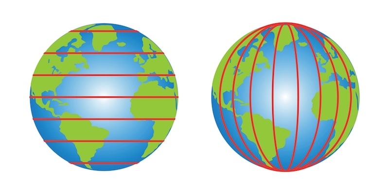
The length, abbreviated long and symbolized by the Greek letter lambda (λ), It is the angular distance between any point on the Earth's surface and the zero meridian also called the Greenwich meridian, since it is located on the outskirts of London, where the former Royal Greenwich Observatory was located. This reference meridian serves to establish the starting point in the count by sexagesimal degrees of the imaginary lines (meridians) that segment the planet like the segments of a tangerine.
Depending on whether the meridians are located to the east or west of the reference meridian, they are called meridians of positive longitude or East longitude (E), or negative longitude or West longitude (W). The division of the planet in terms of east and west is not as exact as that proposed by the northern and southern hemispheres, but allows you to establish the different time zones in the world.
These bands are known as time zones, and are determined from the meridians, in such a way that hours are added or subtracted from the time established along the Greenwich meridian, depending on whether the longitude of the new place is positive. or negative respectively.
Thus, for example, the time zone of the Chinese capital, Beijing, is GMT+8 (from English Greenwich Meridian Time +8, that is, “Greenwich Mean Time +8”), while the time zone of the capital of Chile, Santiago, is GMT-4. In a similar way, The imaginary line obtained by projecting the zero meridian to the other side of the planet is the international date line: the point on the planet at which, by convention, each new day begins.
The geographic coordinate system
Together, latitude and longitude, that is, parallels and meridians, constitute a grid that allows viewing the geographic coordinate system. So the coordinates are expressed through sexagesimal degrees, always based on two relevant data: latitude and longitude, with which it is possible to find any desired point on the globe. With this information, navigation and long-distance travel were undertaken for centuries, and Current GPS systems also operate with them.
There are different conventions and designs of this system, since since the planet is not a perfect circle, projections and equivalences must be made for the geometric system to work perfectly. The most used system is the Universal Mercator Geographic Coordinate System (UTM), which comes from the most accepted and used geometric projection in the world, made by the German Gerardus Mercator (1512-1594) in 1569.
Examples of geographic coordinates
Some examples of geographic coordinates of the world are:
- Mexico City, Mexico: 19°25'42'' N and 99°7'66'' W
- Buenos Aires, Argentina: 34°36'47'' S and 58°22'63'' W
- Vatican City, Italy: 41°54'10'' N and 12°27'20'' E
- Ljubljana, Slovenia: 46°3'3'' N and 14°30'30'' E
- Sydney, Australia: 33°52'4'' S and 151°12'43'' E
- Shanghai, China: 31°13'20'' N and 121°27'48'' E
- Guayaquil, Ecuador: 2°11'46'' S and 79°53'17'' W
- Doha, Qatar: 25°17'7'' N and 51°31'85'' E
How to know your exact geographical coordinates?
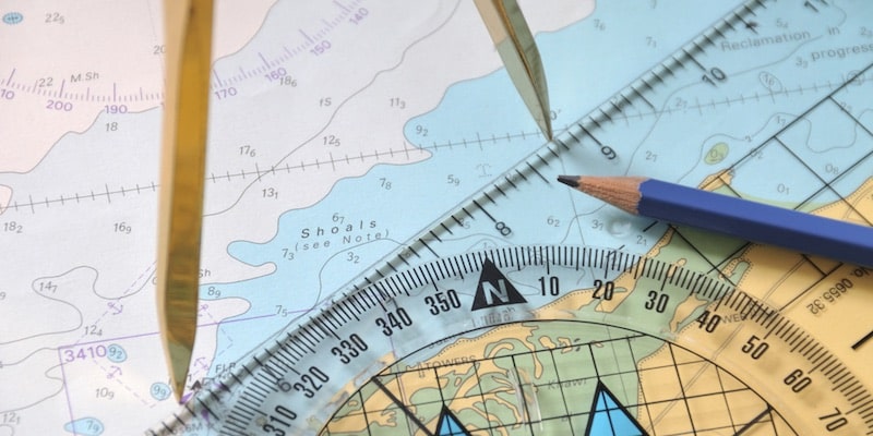
To determine the exact geographical coordinates of a place, simply use a digital geolocation tool like Google Maps: on the location sheet of any point on the map, the two figures of the coordinates will appear. You can also use online search engines for geographic coordinates such as Geodata or GPS-Coordinates.
Continue with: Cartography
References
- “Geographic coordinates” on Wikipedia.
- “Geographic coordinates” in GCF Learn Free.
- “Geographic Coordinate System” at IBM.
- “Latitude and longitude (geography)” in The Encyclopaedia Britannica.


